
RedKalion
Constantinople Drawing Map Art Print | Historical Cartography | RedKalion
Constantinople Drawing Map Art Print | Historical Cartography | RedKalion
Couldn't load pickup availability
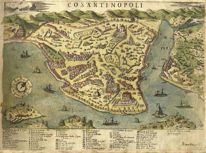
This Constantinople drawing map art print captures a pivotal moment in cartographic history, depicting the Byzantine capital before its transformation into Istanbul. Created during the Renaissance era, such maps blended empirical observation with artistic embellishment, serving as both navigational tools and symbols of imperial power. The intricate detailing reflects the city's strategic importance as a bridge between Europe and Asia, with landmarks like the Hagia Sophia and city walls rendered in precise, hand-drawn lines.
Artistic and Historical Context of This Constantinople Map
Dating to the 16th or 17th century, this antique map of Constantinople exemplifies the transition from medieval mappa mundi to early modern cartography. Stylistically, it combines topographic accuracy with decorative elements like compass roses and sailing ships, characteristic of portolan charts. The map's orientation and scale reveal the cartographer's reliance on traveler accounts and classical texts, offering insights into European perceptions of the Ottoman Empire.
Why This Constantinople Drawing Map Print Is a Collectible Piece
As a fine art print, this piece appeals to historians, collectors, and design enthusiasts seeking authentic historical decor. RedKalion's reproduction preserves the original's patina and line work, making it suitable for scholarly reference or aesthetic display. The map's narrative quality—charting a city at the crossroads of civilizations—adds depth to any interior space, from studies to galleries.
Print Specifications & Materials
- Available Sizes: 75×100 cm / 30×40″, 40×50 cm / 16×20″, 21×29.7 cm / 8×12″
- Paper Finishing: Matte, uncoated, natural white (off-white)
- Acid-Free: pH above 7 to prevent yellowing over time
- Paper Weight: 250 gsm (110 lb) | Thickness: 0.29 mm (11.4 mils)
- Sustainable Paper: FSC-certified
This Constantinople drawing map art print from RedKalion offers a tangible connection to cartographic heritage, reproduced with archival materials for lasting value. Ideal for educational or decorative use, it embodies the fusion of art and science that defined early mapmaking.


Discover Unlimited Art Possibilities
At RedKalion, you can find virtually any artwork from any artist, available in a wide range of sizes to perfectly match your space.
If you didn’t find what you’re looking for, contact us at support@redkalion.com . We will source any artwork and produce it in any size and format you need, including art prints, posters, canvas, framed pieces, framed canvas, and more.
For dedicated art enthusiasts, we also offer handcrafted replicas of any artwork, carefully painted by highly skilled artists using traditional techniques.
For custom requests, contact us at support@redkalion.com .
What is the historical period of this Constantinople drawing map?
This map dates to the Renaissance era, likely 16th-17th century, reflecting early modern cartography techniques and European views of the Ottoman Empire.
What are the key landmarks shown on this antique map of Constantinople?
The map includes the Hagia Sophia, city walls, and the Golden Horn, depicted with hand-drawn precision typical of historical portolan charts.
What paper is used for this fine art print of Constantinople?
We use FSC-certified, acid-free paper with a matte finish, 250 gsm weight, and natural white color for archival quality and authentic reproduction.
How is this Constantinople map print shipped and packaged?
Prints are shipped flat in protective packaging to prevent damage, with global delivery options and tracking for secure antique map art transport.
Will this drawing map print fade or yellow over time?
No, the acid-free paper and archival inks ensure long-term color stability, preventing yellowing for decades under normal display conditions.
How does this map differ from later Istanbul cartography?
It predates modern surveys, emphasizing artistic embellishment and symbolic elements over strict accuracy, capturing Constantinople's pre-Ottoman transformation.
What makes this a museum-quality reproduction?
RedKalion uses high-resolution scanning and color-matching to replicate original details, ensuring historical fidelity in this cartographic art print.