
RedKalion
Lake Erie Depth Chart Art Print | Nautical Survey Map | RedKalion
Lake Erie Depth Chart Art Print | Nautical Survey Map | RedKalion
Couldn't load pickup availability
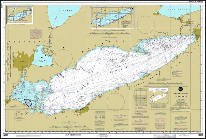
This Lake Erie depth chart art print presents a 2024 NOAA and NOS survey, transforming precise hydrographic data into a striking visual statement. The map details bathymetric contours, navigational hazards, and coastal features with scientific clarity. Its minimalist aesthetic, rooted in functional cartography, offers a modern interpretation of Great Lakes geography.
Lake Erie Depth Chart as Fine Art
NOAA's National Ocean Service (NOS) employs advanced sonar and satellite technology to create these authoritative charts. The Lake Erie depth chart reveals underwater topography, from shallow shoals to the deep central basin. This print captures that data-driven artistry, blending utility with graphic elegance for coastal or nautical decor.
Historical and Stylistic Context of Nautical Maps
Modern charts like this Lake Erie depth chart descend from centuries of maritime exploration. Unlike decorative antique maps, it prioritizes accuracy for safe navigation. The color-coded depth gradients and clear typography reflect a legacy of scientific surveying, updated annually to ensure reliability for boaters and researchers alike.
Print Specifications & Materials
- Available Sizes: 75×100 cm / 30×40″, 40×50 cm / 16×20″, 21×29.7 cm / 8×12″
- Paper Finishing: Matte, uncoated, natural white (off-white)
- Acid-Free: pH above 7 to prevent yellowing over time
- Paper Weight: 250 gsm (110 lb) | Thickness: 0.29 mm (11.4 mils)
- Sustainable Paper: FSC-certified
RedKalion's archival print of this Lake Erie depth chart ensures lasting quality, ideal for educational or decorative display. Trust our museum-grade standards for a piece that honors both cartographic precision and contemporary design.


Discover Unlimited Art Possibilities
At RedKalion, you can find virtually any artwork from any artist, available in a wide range of sizes to perfectly match your space.
If you didn’t find what you’re looking for, contact us at support@redkalion.com . We will source any artwork and produce it in any size and format you need, including art prints, posters, canvas, framed pieces, framed canvas, and more.
For dedicated art enthusiasts, we also offer handcrafted replicas of any artwork, carefully painted by highly skilled artists using traditional techniques.
For custom requests, contact us at support@redkalion.com .
What does this Lake Erie depth chart art print depict?
This print features the 2024 NOAA and NOS survey of Lake Erie, showing detailed bathymetric data, navigational markers, and coastal outlines for accurate nautical reference.
What are the paper specifications for this nautical chart print?
It uses 250 gsm, acid-free, FSC-certified paper with a matte finish to ensure archival longevity and reduce glare, suitable for framing and display.
How is shipping handled for fine art prints?
Prints are shipped flat in protective packaging to prevent damage, with tracking provided. Delivery times vary by location but typically within 5-10 business days.
Will this Lake Erie map print fade or yellow over time?
No, the acid-free paper and archival inks resist fading and yellowing, preserving the chart's clarity and colors for decades under normal indoor conditions.
Who created the original Lake Erie depth chart?
The National Oceanic and Atmospheric Administration (NOAA) and its National Ocean Service (NOS) produce these official surveys using sonar and satellite data for maritime safety.
What makes this depth chart suitable for home or office decor?
Its clean, data-driven design combines scientific accuracy with minimalist aesthetics, offering a sophisticated piece for nautical, coastal, or educational interiors.