
RedKalion
Map of Ancient Gaul Art Print | Premium Historical Map | RedKalion
Map of Ancient Gaul Art Print | Premium Historical Map | RedKalion
Couldn't load pickup availability
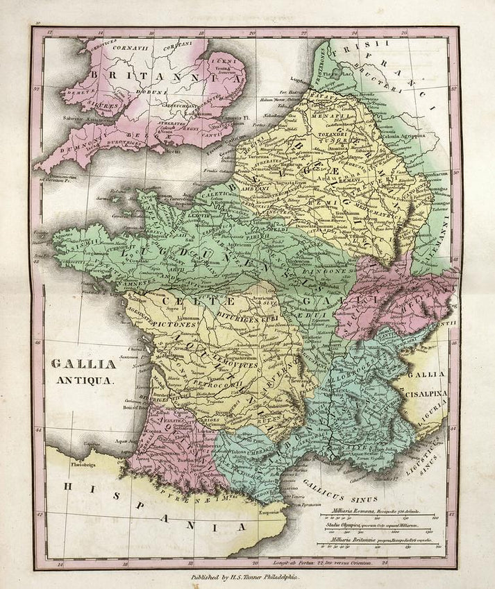
This Map of Ancient Gaul art print offers a detailed cartographic depiction of the region that encompassed modern-day France, Belgium, and parts of Switzerland, Germany, and Italy during the pre-Roman and Roman eras. Created as a scholarly reconstruction, it illustrates tribal territories, major settlements like Lugdunum (Lyon) and Lutetia (Paris), and natural features such as the Rhine and Alps, serving as an essential visual reference for understanding Celtic and Gallo-Roman history.
Historical Context of This Ancient Gaul Map
Ancient Gaul, known as Gallia to the Romans, was a culturally diverse area inhabited by Celtic tribes before Julius Caesar's conquest in the 1st century BCE. This map synthesizes archaeological findings and classical sources like Caesar's Commentarii de Bello Gallico to present a nuanced view of political boundaries and trade routes, reflecting the complex interactions between indigenous Gauls and Roman influences.
Stylistic Analysis of the Gaul Map Artwork
Rendered in a classic cartographic style, this print employs precise linework and subdued earth tones to evoke historical authenticity. The typography and symbolic elements, such as tribal icons and topographic shading, are designed for clarity and educational value, making it a sophisticated piece for historians, educators, and art enthusiasts seeking a tangible connection to antiquity.
Print Specifications & Materials
- Available Sizes: 75×100 cm / 30×40″, 40×50 cm / 16×20″, 21×29.7 cm / 8×12″
- Paper Finishing: Matte, uncoated, natural white (off-white)
- Acid-Free: pH above 7 to prevent yellowing over time
- Paper Weight: 250 gsm (110 lb) | Thickness: 0.29 mm (11.4 mils)
- Sustainable Paper: FSC-certified
At RedKalion, we specialize in museum-quality reproductions that honor historical accuracy and artistic integrity. This map of ancient Gaul is printed on archival-grade materials, ensuring it remains a durable and insightful addition to any collection, whether for academic study or decorative appreciation.

Discover Unlimited Art Possibilities
At RedKalion, you can find virtually any artwork from any artist, available in a wide range of sizes to perfectly match your space.
If you didn’t find what you’re looking for, contact us at support@redkalion.com . We will source any artwork and produce it in any size and format you need, including art prints, posters, canvas, framed pieces, framed canvas, and more.
For dedicated art enthusiasts, we also offer handcrafted replicas of any artwork, carefully painted by highly skilled artists using traditional techniques.
For custom requests, contact us at support@redkalion.com .
What does this map of Gaul depict?
This map shows Ancient Gaul's tribal regions, cities like Lutetia, and natural landmarks, based on historical and archaeological sources for accuracy.
What paper is used for this ancient Gaul map print?
We use FSC-certified, acid-free 250 gsm matte paper to ensure archival longevity and a premium, non-reflective finish.
How is this Gaul map shipped and packaged?
Prints are shipped flat in protective packaging to prevent damage, with tracking provided for secure delivery worldwide.
Will this map of ancient Gaul fade over time?
No, the acid-free paper and pigment-based inks resist fading, maintaining color stability for decades under proper display conditions.
What sizes are available for this Gaul map art print?
Available in 75×100 cm, 40×50 cm, and 21×29.7 cm to suit different spaces, from study rooms to offices.
Which tribes are featured on this map of Gaul?
It includes major tribes like the Helvetii, Aedui, and Belgae, highlighting their territories and cultural significance in pre-Roman Gaul.
How was this ancient Gaul map historically sourced?
Based on Roman accounts and modern archaeology, it reconstructs boundaries from the late Iron Age to early Roman period for educational use.