
RedKalion
Map of the Main Rivers and Canals in England Art Print | RedKalion
Map of the Main Rivers and Canals in England Art Print | RedKalion
Couldn't load pickup availability
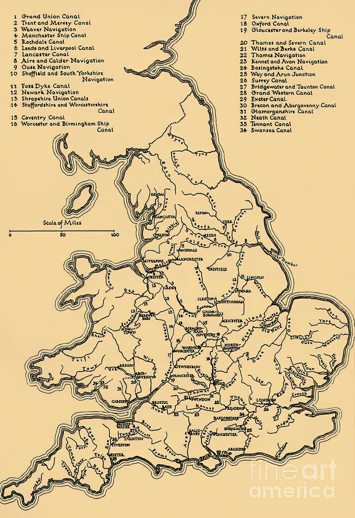
This detailed historical map of English rivers and canals offers a fascinating glimpse into England's industrial and geographical heritage. Created during the 18th or 19th century, it charts the vital waterways that fueled trade, transportation, and economic growth across the nation. The map combines cartographic precision with period-specific aesthetic, featuring intricate linework and typography.
Historical Context of English Rivers and Canals
The network depicted represents the engineering marvels of the Industrial Revolution. Canals like the Grand Junction and rivers such as the Thames and Trent were lifelines for commerce, connecting ports, cities, and industrial hubs. This map serves as a visual record of a transformative era in English history.
Artistic and Cartographic Analysis
Stylistically, the map reflects the Enlightenment's emphasis on accuracy and order. It employs a clear, functional design with labeled routes, settlements, and topographic features. The muted color palette and engraved details are typical of historical cartography, prioritizing legibility and utility over decorative flourish.
Print Specifications & Materials
- Available Sizes: 75×100 cm / 30×40″, 40×50 cm / 16×20″, 21×29.7 cm / 8×12″
- Paper Finishing: Matte, uncoated, natural white (off-white)
- Acid-Free: pH above 7 to prevent yellowing over time
- Paper Weight: 250 gsm (110 lb) | Thickness: 0.29 mm (11.4 mils)
- Sustainable Paper: FSC-certified
At RedKalion, we specialize in museum-quality reproductions that honor the original's detail and historical significance. This fine art print of English rivers and canals is produced with archival materials, ensuring it remains a durable and educational piece for your home or office.


Discover Unlimited Art Possibilities
At RedKalion, you can find virtually any artwork from any artist, available in a wide range of sizes to perfectly match your space.
If you didn’t find what you’re looking for, contact us at support@redkalion.com . We will source any artwork and produce it in any size and format you need, including art prints, posters, canvas, framed pieces, framed canvas, and more.
For dedicated art enthusiasts, we also offer handcrafted replicas of any artwork, carefully painted by highly skilled artists using traditional techniques.
For custom requests, contact us at support@redkalion.com .
What historical period does this map of English rivers and canals represent?
This map depicts the network of English rivers and canals primarily from the 18th and 19th centuries, during the peak of the Industrial Revolution when these waterways were critical for trade and transport.
What are the key rivers and canals shown on this map?
Major features include the River Thames, River Trent, Grand Junction Canal, and other significant English rivers and canals that connected industrial centers across England.
What type of paper is used for this fine art print?
We use FSC-certified, acid-free paper with a matte finish, weighing 250 gsm, to ensure archival quality and prevent yellowing for your English rivers map print.
How is this art print shipped to protect it?
Prints are carefully rolled in a sturdy tube with protective layers to prevent damage during shipping, ensuring your map of English rivers arrives in perfect condition.
How long will this print last without fading or damage?
With acid-free, archival materials, this print of English rivers and canals is designed to resist fading and deterioration for decades under normal indoor display conditions.
What makes this map stylistically significant in cartographic history?
It exemplifies Enlightenment-era cartography with precise linework, functional design, and a focus on accurately mapping English rivers and canals for practical use during industrialization.
Can this print be customized in size or framing?
Yes, we offer multiple standard sizes for this English rivers map print; contact us for custom sizing or framing options to suit your display needs.