
RedKalion
Orinoco River Map Art Print | Historical Cartography | RedKalion
Orinoco River Map Art Print | Historical Cartography | RedKalion
Couldn't load pickup availability
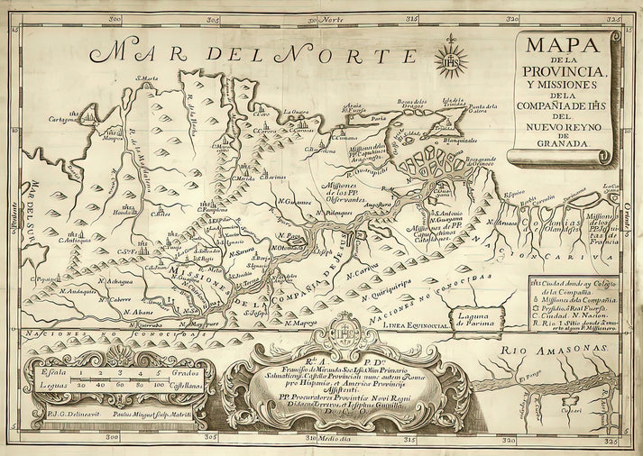
This Orinoco River map art print captures a pivotal moment in the history of cartography, blending scientific exploration with artistic craftsmanship. Originating from the 18th or 19th century, such maps were instrumental in documenting the uncharted territories of South America, with the Orinoco River serving as a critical artery for navigation and colonial expansion. The intricate linework and delicate hand-coloring reflect the era's dedication to accuracy and aesthetic appeal, making this piece a testament to the golden age of mapmaking.
Artistic and Historical Significance of the Orinoco River Map
As a fine art print, this Orinoco River map showcases stylistic elements typical of European cartographers, who often embellished geographical features with decorative cartouches, compass roses, and topographical details. The map's composition emphasizes the river's meandering path through Venezuela and Colombia, highlighting its role in trade and exploration. For collectors, it offers a nuanced glimpse into how early mapmakers interpreted the New World, blending empirical data with imaginative flourishes.
Why This Orinoco River Map Print Is a Timeless Addition
Beyond its historical value, this map of the Orinoco River appeals to modern audiences for its visual depth and educational merit. The muted color palette and precise engraving techniques ensure it complements both traditional and contemporary interiors. RedKalion's reproduction preserves every detail, from river tributaries to coastal outlines, allowing viewers to appreciate the artistry behind early South American cartography.
Print Specifications & Materials
- Available Sizes: 75×100 cm / 30×40″, 40×50 cm / 16×20″, 21×29.7 cm / 8×12″
- Paper Finishing: Matte, uncoated, natural white (off-white)
- Acid-Free: pH above 7 to prevent yellowing over time
- Paper Weight: 250 gsm (110 lb) | Thickness: 0.29 mm (11.4 mils)
- Sustainable Paper: FSC-certified
Ideal for historians, travelers, and art enthusiasts, this Orinoco River map print from RedKalion offers a museum-quality reproduction that honors the legacy of exploration. Display it to inspire curiosity about South America's geographical heritage.


Discover Unlimited Art Possibilities
At RedKalion, you can find virtually any artwork from any artist, available in a wide range of sizes to perfectly match your space.
If you didn’t find what you’re looking for, contact us at support@redkalion.com . We will source any artwork and produce it in any size and format you need, including art prints, posters, canvas, framed pieces, framed canvas, and more.
For dedicated art enthusiasts, we also offer handcrafted replicas of any artwork, carefully painted by highly skilled artists using traditional techniques.
For custom requests, contact us at support@redkalion.com .
What are the dimensions available for this Orinoco River map art print?
This fine art print is available in three sizes: 75×100 cm (30×40 inches), 40×50 cm (16×20 inches), and 21×29.7 cm (8×12 inches), suitable for various framing and display needs.
Is the paper used for this map print archival and acid-free?
Yes, the paper is acid-free with a pH above 7 to prevent yellowing, ensuring long-term preservation and archival quality for your Orinoco River map.
How is this Orinoco River map print shipped to protect it during transit?
We ship prints in sturdy, flat packaging with protective layers to prevent damage, ensuring your historical map arrives in perfect condition for display.
Can this map print be framed without glass to reduce glare?
Yes, the matte, uncoated paper finish minimizes glare, making it ideal for framing without glass while maintaining the Orinoco River map's detailed appearance.
What historical period does this Orinoco River map originate from?
This map dates to the 18th or 19th century, reflecting European cartographic techniques used during South American exploration and colonial mapping efforts.
What makes the Orinoco River significant in this map's depiction?
The map highlights the Orinoco River's role as a major waterway in Venezuela and Colombia, emphasizing its importance for navigation and trade in historical South America.