
RedKalion
Prince William Sound Alaska Nautical Chart Map 2023 Art Print | RedKalion
Prince William Sound Alaska Nautical Chart Map 2023 Art Print | RedKalion
Couldn't load pickup availability
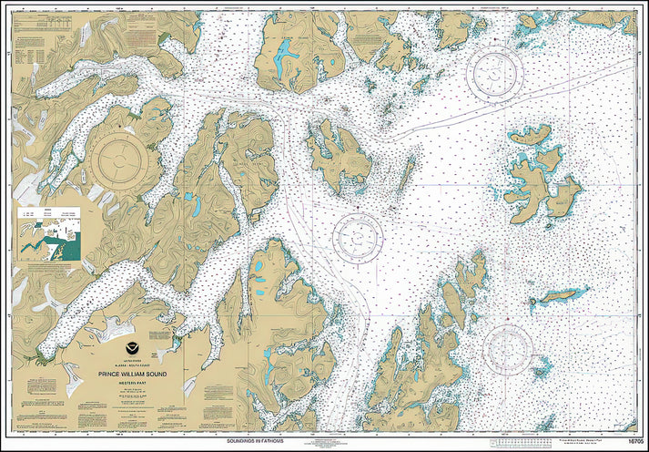
This 2023 Prince William Sound Alaska nautical chart map art print offers a precise cartographic depiction of this iconic Alaskan waterway. Created for navigational accuracy, it details coastal contours, bathymetric data, and navigational aids, serving as both a functional maritime tool and a striking piece of wall art.
Historical & Cartographic Context of This Prince William Sound Map
Prince William Sound, named for the future King William IV by Captain James Cook in 1778, has been charted since the 18th century. This 2023 edition reflects modern hydrographic surveys, capturing the sound's complex fjords, islands like Montague and Hinchinbrook, and the Columbia Glacier terminus. The map's technical rigor ensures it meets contemporary NOAA standards while its aesthetic clarity makes it suitable for display.
Design & Stylistic Analysis of the Nautical Chart
The map employs a restrained color palette typical of nautical charts: deep blues for water, subtle gradients for depth soundings, and crisp black typography for place names. Its grid system and compass roses provide orientation, while the inclusion of latitude/longitude lines underscores its scientific precision. This design balances utility with visual elegance, avoiding decorative excess.
RedKalion's reproduction maintains the chart's original integrity, using archival-grade materials to ensure longevity. The uncoated matte paper minimizes glare, preserving the map's legibility and subtle tonal variations.
Print Specifications & Materials
- Available Sizes: 75×100 cm / 30×40″, 40×50 cm / 16×20″, 21×29.7 cm / 8×12″
- Paper Finishing: Matte, uncoated, natural white (off-white)
- Acid-Free: pH above 7 to prevent yellowing over time
- Paper Weight: 250 gsm (110 lb) | Thickness: 0.29 mm (11.4 mils)
- Sustainable Paper: FSC-certified
Ideal for maritime enthusiasts, historians, or those seeking a sophisticated geographic accent, this Prince William Sound map art print combines authoritative cartography with RedKalion's commitment to museum-quality reproduction.


Discover Unlimited Art Possibilities
At RedKalion, you can find virtually any artwork from any artist, available in a wide range of sizes to perfectly match your space.
If you didn’t find what you’re looking for, contact us at support@redkalion.com . We will source any artwork and produce it in any size and format you need, including art prints, posters, canvas, framed pieces, framed canvas, and more.
For dedicated art enthusiasts, we also offer handcrafted replicas of any artwork, carefully painted by highly skilled artists using traditional techniques.
For custom requests, contact us at support@redkalion.com .
What does this Prince William Sound Alaska nautical chart map depict?
This 2023 art print shows Prince William Sound's coastal geography, bathymetric data, navigational aids, and key landmarks like Columbia Glacier, based on official NOAA hydrographic surveys.
What paper is used for this fine art print of the map?
We use 250 gsm, acid-free, FSC-certified matte paper with a natural white finish to ensure archival longevity and reduce glare for clear map viewing.
How is this nautical chart map art print shipped?
Prints are shipped flat in protective packaging to prevent damage, with tracking provided. Delivery times vary by location.
How long will this archival art print last without fading?
With acid-free paper and pigment-based inks, this print resists yellowing and fading for decades under normal display conditions, away from direct sunlight.
What historical significance does Prince William Sound have?
Named in 1778 by Captain Cook, it's a historic Alaskan waterway known for its glaciers, wildlife, and role in maritime exploration and the 1989 Exxon Valdez oil spill.
What are the key cartographic features on this map?
It includes depth soundings, latitude/longitude grids, compass roses, coastal contours, and navigational symbols, adhering to modern nautical charting standards for accuracy.