
Karte der Hauptflüsse und Kanäle in England Kunstdruck | RedKalion
Karte der Hauptflüsse und Kanäle in England Kunstdruck | RedKalion
Verfügbarkeit für Abholungen konnte nicht geladen werden
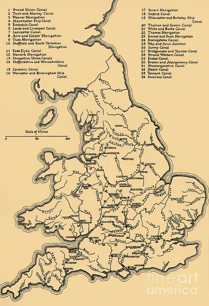
Diese detaillierte historische Karte englischer Flüsse und Kanäle bietet einen faszinierenden Einblick in Englands industrielles und geografisches Erbe. Erstellt im 18. oder 19. Jahrhundert, verzeichnet sie die wichtigen Wasserwege, die Handel, Transport und wirtschaftliches Wachstum im ganzen Land befeuerten. Die Karte verbindet kartografische Präzision mit zeitspezifischer Ästhetik und zeigt dabei filigrane Linienführung und Typografie.
Historischer Kontext englischer Flüsse und Kanäle
Das dargestellte Netzwerk steht für die ingenieurtechnischen Meisterleistungen der Industriellen Revolution. Kanäle wie der Grand Junction und Flüsse wie die Themse und der Trent waren Lebensadern für den Handel, die Häfen, Städte und Industriezentren verbanden. Diese Karte dient als visuelle Aufzeichnung einer transformativen Epoche der englischen Geschichte.
Künstlerische und kartografische Analyse
Stilistisch spiegelt die Karte den aufklärerischen Fokus auf Genauigkeit und Ordnung wider. Sie verwendet ein klares, funktionales Design mit beschrifteten Routen, Siedlungen und topografischen Merkmalen. Die gedeckte Farbpalette und die gravierten Details sind typisch für historische Kartografie und priorisieren Lesbarkeit und Nützlichkeit gegenüber dekorativer Ausschmückung.
Druckspezifikationen & Materialien
- Verfügbare Größen: 75×100 cm / 30×40″, 40×50 cm / 16×20″, 21×29,7 cm / 8×12″
- Papierveredelung: Matt, ungestrichen, natürliches Weiß (cremeweiß)
- Säurefrei: pH-Wert über 7, um Vergilben mit der Zeit zu verhindern
- Papiergewicht: 250 g/m² (110 lb) | Dicke: 0,29 mm (11,4 mils)
- Nachhaltiges Papier: FSC-zertifiziert
Bei RedKalion spezialisieren wir uns auf museumswürdige Reproduktionen, die die Details und historische Bedeutung des Originals ehren. Dieser hochwertige Kunstdruck englischer Flüsse und Kanäle wird mit archivbeständigen Materialien hergestellt und bleibt so ein langlebiges und lehrreiches Stück für Ihr Zuhause oder Büro.
```

Discover Unlimited Art Possibilities
At RedKalion, you can find virtually any artwork from any artist, available in a wide range of sizes to perfectly match your space.
If you didn’t find what you’re looking for, contact us at support@redkalion.com . We will source any artwork and produce it in any size and format you need, including art prints, posters, canvas, framed pieces, framed canvas, and more.
For dedicated art enthusiasts, we also offer handcrafted replicas of any artwork, carefully painted by highly skilled artists using traditional techniques.
For custom requests, contact us at support@redkalion.com .
What historical period does this map of English rivers and canals represent?
This map depicts the network of English rivers and canals primarily from the 18th and 19th centuries, during the peak of the Industrial Revolution when these waterways were critical for trade and transport.
What are the key rivers and canals shown on this map?
Major features include the River Thames, River Trent, Grand Junction Canal, and other significant English rivers and canals that connected industrial centers across England.
What type of paper is used for this fine art print?
We use FSC-certified, acid-free paper with a matte finish, weighing 250 gsm, to ensure archival quality and prevent yellowing for your English rivers map print.
How is this art print shipped to protect it?
Prints are carefully rolled in a sturdy tube with protective layers to prevent damage during shipping, ensuring your map of English rivers arrives in perfect condition.
How long will this print last without fading or damage?
With acid-free, archival materials, this print of English rivers and canals is designed to resist fading and deterioration for decades under normal indoor display conditions.
What makes this map stylistically significant in cartographic history?
It exemplifies Enlightenment-era cartography with precise linework, functional design, and a focus on accurately mapping English rivers and canals for practical use during industrialization.
Can this print be customized in size or framing?
Yes, we offer multiple standard sizes for this English rivers map print; contact us for custom sizing or framing options to suit your display needs.