
Prince-William-Sund Alaska Nautische Karte 2023 Kunstposter | RedKalion
Prince-William-Sund Alaska Nautische Karte 2023 Kunstposter | RedKalion
Verfügbarkeit für Abholungen konnte nicht geladen werden
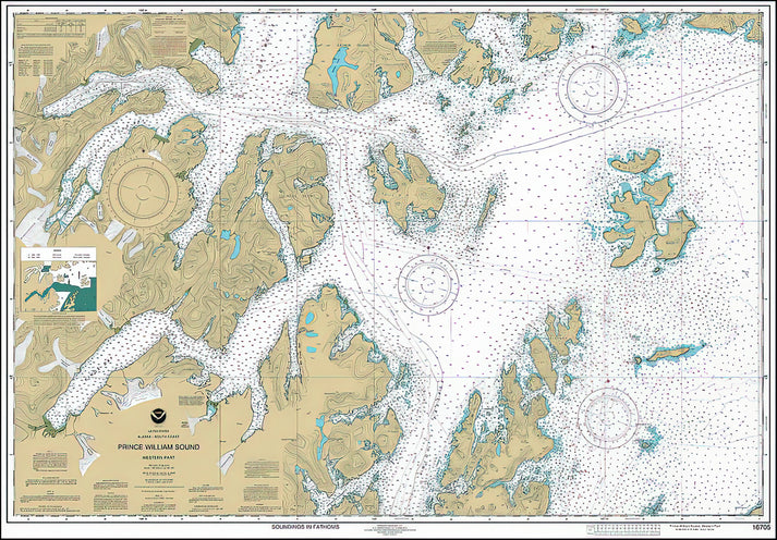
Dieser nautische Kartendruck der Prince-William-Sound-Karte aus Alaska aus dem Jahr 2023 bietet eine präzise kartografische Darstellung dieses ikonischen Gewässers in Alaska. Erstellt für navigatorische Genauigkeit, zeigt er Küstenverläufe, bathymetrische Daten und Navigationshilfen und dient sowohl als funktionales maritimes Werkzeug als auch als beeindruckendes Wandkunstwerk.
Historischer & kartografischer Kontext dieser Prince-William-Sound-Karte
Prince William Sound, benannt nach dem späteren König William IV. von Captain James Cook im Jahr 1778, wird seit dem 18. Jahrhundert kartografiert. Diese Ausgabe aus dem Jahr 2023 spiegelt moderne hydrographische Vermessungen wider und erfasst die komplexen Fjorde des Sunds, Inseln wie Montague und Hinchinbrook sowie den Gletscherterminus des Columbia-Gletschers. Die technische Präzision der Karte stellt sicher, dass sie den aktuellen NOAA-Standards entspricht, während ihre ästhetische Klarheit sie für die Präsentation geeignet macht.
Design- und Stilanalyse der nautischen Karte
Die Karte verwendet eine zurückhaltende Farbpalette, die typisch für nautische Karten ist: tiefes Blau für Gewässer, subtile Verläufe für Tiefenangaben und scharfe schwarze Schrift für Ortsnamen. Ihr Gittersystem und Kompassrosen bieten Orientierung, während die Einbindung von Breiten- und Längengradlinien ihre wissenschaftliche Präzision unterstreicht. Dieses Design vereint Funktionalität mit visueller Eleganz und verzichtet auf überflüssige Dekoration.
Die Reproduktion von RedKalion bewahrt die ursprüngliche Integrität der Karte und verwendet archivbeständige Materialien, um Langlebigkeit zu gewährleisten. Das ungestrichene Mattpapier minimiert Reflexionen und erhält so die Lesbarkeit der Karte sowie ihre subtilen Tonabstufungen.
Druckspezifikationen & Materialien
- Verfügbare Größen: 75×100 cm / 30×40″, 40×50 cm / 16×20″, 21×29,7 cm / 8×12″
- Papierfinish: Matt, ungestrichen, natürliches Weiß (cremeweiß)
- Säurefrei: pH-Wert über 7, um Vergilben mit der Zeit zu verhindern
- Papiergewicht: 250 g/m² (110 lb) | Dicke: 0,29 mm (11,4 mils)
- Nachhaltiges Papier: FSC-zertifiziert
Ideal für maritime Enthusiasten, Historiker oder alle, die einen anspruchsvollen geografischen Akzent suchen, vereint diese Prince-William-Sound-Karten-Kunst mit RedKalions Engagement für museumswürdige Reproduktionen.
```

Discover Unlimited Art Possibilities
At RedKalion, you can find virtually any artwork from any artist, available in a wide range of sizes to perfectly match your space.
If you didn’t find what you’re looking for, contact us at support@redkalion.com . We will source any artwork and produce it in any size and format you need, including art prints, posters, canvas, framed pieces, framed canvas, and more.
For dedicated art enthusiasts, we also offer handcrafted replicas of any artwork, carefully painted by highly skilled artists using traditional techniques.
For custom requests, contact us at support@redkalion.com .
What does this Prince William Sound Alaska nautical chart map depict?
This 2023 art print shows Prince William Sound's coastal geography, bathymetric data, navigational aids, and key landmarks like Columbia Glacier, based on official NOAA hydrographic surveys.
What paper is used for this fine art print of the map?
We use 250 gsm, acid-free, FSC-certified matte paper with a natural white finish to ensure archival longevity and reduce glare for clear map viewing.
How is this nautical chart map art print shipped?
Prints are shipped flat in protective packaging to prevent damage, with tracking provided. Delivery times vary by location.
How long will this archival art print last without fading?
With acid-free paper and pigment-based inks, this print resists yellowing and fading for decades under normal display conditions, away from direct sunlight.
What historical significance does Prince William Sound have?
Named in 1778 by Captain Cook, it's a historic Alaskan waterway known for its glaciers, wildlife, and role in maritime exploration and the 1989 Exxon Valdez oil spill.
What are the key cartographic features on this map?
It includes depth soundings, latitude/longitude grids, compass roses, coastal contours, and navigational symbols, adhering to modern nautical charting standards for accuracy.